The Digital Revolution
GIS has revolutionized the way the Forest Industry collects, tracks and displays resource information. Layers of geographical data are analyzed to aid in all levels of harvest planning. Digital inventories of timber and elevations are used to develop the Timber Supply Analysis. Harvest designs are tracked in spatial layers and overlaid onto base data. Laid out cutblock boundaries and road center-lines are located using Global Positioning Systems (GPS) data collectors. Operational Maps are developed using GPS data and base data.
Global Positioning Systems
The GPS System is a constellation of 24 satellites, which orbit the earth twice a day approximately 12,000 miles above the earth. These satellites transmit precise time and position information that can be obtained using a GPS receiver to determine its location anywhere on earth. The GPS receiver needs to obtain signals from 3 or more satellites in order to generate an accurate position. Spray Lake Sawmills uses GPS to collect information for its operations. The GPS receivers we use are also data loggers that collect numerous geographical points. This makes it possible to quickly and accurately locate features in the forest and transfer the information into our GIS system.
Mapping
Data layers can be viewed and mapped using many combinations, depending on what information is pertinent. Below are a few examples using the same focus area with different data layers.
Visualizations
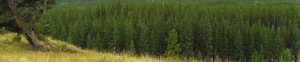
Using the Alberta Vegetation Inventory (AVI) layer and a Digital Elevation Model (DEM), images are created to observe the visual impact our harvesting will have from chosen locations. This is a valuable tool for planners to ensure aesthetic values are addressed. An image created from computer software before harvesting using preliminary boundaries and a photo taken after harvesting was completed from the location specified, are shown below.
Obtaining Spatial Data
Resource data collection and management has become a much more complex process than ever before. With the advent of digital data bases, GIS technology (Geographic Information System), and instantaneous electronic transfer of information issues of proprietary rights, intellectual property, data manipulation and re-distribution have become important considerations in managing data files. Through a combination of various data sharing and data licensing agreements, Spray Lake Sawmills has been able to improve the delivery of an in-house GIS program. The opportunities for sharing data among various companies and organizations has resulted in an improved cost effectiveness and ability to analyze and map resource information.
A variety of digital data bases can be accessed through Spatial Data Warehouse Ltd. This is a non-profit organization that assumed the handling of spatial data from the provincial government in 1996. The agent in charge of the distribution of spatial data is AltaLIS Ltd. Products and services are available on-line at www.altalis.com.

