Members of Spray Lakes’ Woodlands team have heard comments/concerns from various people about our proposed harvest plans, the most recent being questions about the plans west of Bragg Creek. How will the recreation trails be impacted and how will it affect the overall recreation values of the area? Will we be seeing trucks and other heavy equipment going through the community? Are there any safety concerns we should be aware of? What will the impacts be on water quality and wildlife? How have plans been changed to accommodate these concerns? All valid questions.
As a way to help provide some answers to these questions we are going to try dipping our toe into the social media. While we may not be able to meet 100% of the peoples concerns 100% of the time we can still do a lot to help find a balance among conflicting landuse activities in the forest reserve. First and foremost is the establishment of a communication link to those that have concerns, those that may have some good suggestions or ideas and those that do the planning within the company. We can’t expect people to be happy and supportive of our plans unless we are able to build a trust and understanding in what we are doing.
To open the dialogue here are a few responses to comments we have heard and how we have attempted to accommodate them. Ask your questions and we will do our best to provide you with a factual response.
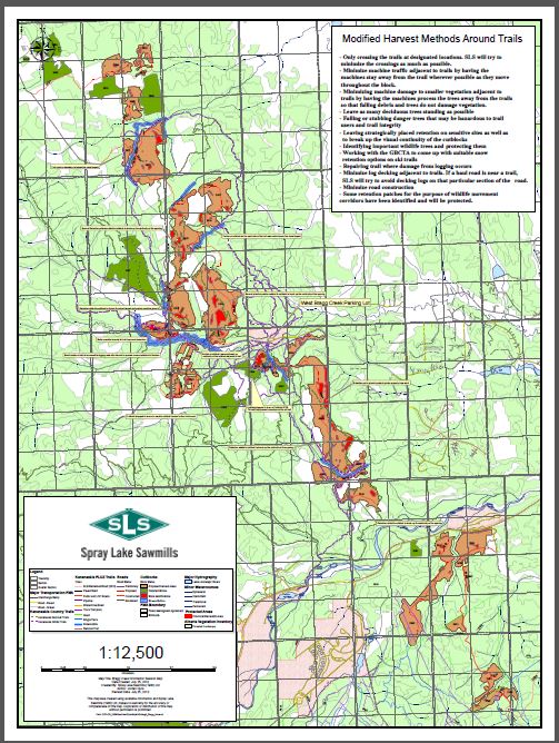
For starters, here is a map of the Bragg Creek plan as it sits right now. Just in case the legend is a little small to make out, the dark green patches are areas that have been deleted from the original plan to reduce impacts on recreation values while still maintaining fire containment objectives. The white patches are mapped as open areas. These are a mix of open meadows or previous reforested blocks from 25 years ago. The light green areas are forested but not part of any current plans for harvesting. The brown are planned for harvesting as part of the fire containment strategy and the red are areas that have been changed, modified or deleted from the original plan to accommodate a mix of concerns that we heard. Trails and watershed retention areas have also been shown.
In the upper right hand corner is an outline of how harvest practices will be modified around rec trails. We estimate that about 12.9% of the West Bragg Creek trail system will go through or alongside a cut area. These trails will need to see a temporary closure during active operations for safety reasons but will be kept open and clear for ongoing use afterwards. Admittedly fresh logging isn’t as aesthetically pleasing as a mature forest but consider how they will look after they have been reforested and green up again. This is part of the balancing act when working in a forest zoned for multiple-use. The concept of buffering all trails resulted in two problems: 1) reduced functionality (increased risk) in meeting fire containment objectives and 2) increased wind exposure and blowdown susceptibility making trails impassable.
Bragg Creek Harvest Design Map
Please click on map for a larger view.
Safety has always been a top priority within our woodlands operations, both for our staff, contractors and general public. We have a time tested program that includes: training, PPE, signage, site hazard assessments, tailgate meetings, inspections and so on. We have heard about concerns with heavy truck traffic going through the community and what impacts there might be on safety, noise and impacts on the road system. As a consequence we have planned an alternate access road which will come down from the north, off of the Sibbald Trail Gun Range Road.
There is a document commonly known as the Operating Ground Rules which outlines best management practices and gives guidelines for operational planning on things such as retention areas around creeks, dealing with critical wildlife areas and so on. This can be found on-line on either ESRD website or Spray Lake Sawmills’ website. Another document that might be of interest is Spray Lake Sawmills Detailed Forest Management Plan (DFMP). This can also be found on both websites mentioned above.
I hope this acts as a start point for some of your questions/concerns. Please respond with any other questions you may have. All the best and I hope to hear back from you.
Gord


I think there are a lot of technology out that you can put a interactive map with better resolution so you can see something better, For example you can have a overlay on Google maps, or a vectorial file that can be zoom without the restriction of a raster file (a simple link to a PDF file generated form a vectorial program)
PS i think a FORUM instead of a blog or a Facebook page could be more productive cooperative tool to keep a OPEN DIALOG.
PPS do you have answers to the “all valid questions” you mention in your introduction?
Hi Alvise
Sorry to hear that our map isn’t doing the job for you. The map has also been posted on Spray Lake sawmills website. You can find it at http://www.spraylakesawmills.com On the front page you will find a section titled “Quick Links” The link is posted at the top of the list. One of the quick links also contains a write-up of the outcome from our open house that was held in Bragg Creek back in January. Hopefully you will find answers to your questions in there. If you still have further questions beyond that please let me know and I will do what I can to help you out.
Gord
Thanks for including me in your mail out. My comments reflect my role as Chairman of the Upper Bow Basin Cumulative Effects Study group.
Our concern is to promote a comprehensive approach, employing all available data when making planning decisions. We advocate using water quality/quantity (for example) as a index to gauge the appropriateness of all actions on the landscape. (Note: there are other indices which also should be considered, but the point is simply that all of our actions have consequences, and we should be aware of these as we proceed with ordinary commerce.
I applaud your effort to become certified and look forward to further helpful discussions in this regard.
All the best in the New Year
Hugh Pepper
Hi Hugh. Its good to hear from you and of your involvement with the Cumulative Effects Study Group. Spray Lake Sawmills is currently working on a Stewardship report of its operations over the last five years. In the report we will be reporting on how well we have been managing against the objectives listed within our Detailed Forest Management Plan. When it is done this report will be posted on the company’s webpage. Perhaps this will be of some help with your study group. All the best.
I would like to take a moment to respond to this comment.
“We can’t expect people to be happy and supportive of our plans unless we are able to build a trust and understanding in what we are doing.”
During the trail mitigation consultation that SLS was required by the ESRD to partake in, we ran into an issue with harvesting block 13. The Eastern half of Block 13 was deemed by the ESRD as unnecessary and eliminated from the fire smart harvest plan. SLS then raised the issue of not being able to easily recover the logs from the western portion of Block 13, unless there was limited logging as required for roading, decking or skidding on the eastern portion. The trails groups trusted that this was a legitimate claim and agreed to this proposal. The resulting plan that SLS put forward included a 40% increase in block size, with logging added to areas that are nowhere near the haul roads, skidding roads or decking areas.
How do you plan on building a trust and understanding by posting a very one sided blog on the logging that you are conducting, when you fail to follow agreements made during consultation?
All of the concessions that were made by SLS to accommodate recreation in this plan, were only done after the minister of the ESRD stepped in and forced SLS to scale back their logging operation. When SLS was in consultation with the trails association prior to the ESRD getting involved, they refused to allow trail buffers and other measures that helped to reduce the impact on recreation.
These actions have developed the deep mistrust that the public has with SLS and a simple blog won’t do anything to repair that mistrust. Show us that you care about recreation and avoid logging in heavy use recreation areas, offer trail buffers without being forced, do minimal logging, not a massive clear cut when the trails groups agree to limited logging for roading, decking and skidding only. These are the ways to earn trust and understanding. These are the ways to ensure that the public supports a mixed use designation allowing logging in an area with over half a million visitors annually.
Thank you for your comments Shaun. We don’t quite recall the events unfolding in the same manner as you describe them but we appreciate the opportunity to clarify some important points.
The Bragg Creek harvest plan was difficult to comes to terms with and get finalized. It involved input from many stakeholders and required the integration of numerous multiple-use resource values. The nature of this type of process inevitably requires flexibility and compromise among participants.
There are elements of this plan which Spray Lake Sawmills did not agree with either but yielded for the sake of finding a solution. For example, our field assessments show the trail buffers may blow down over time and create problems for long term trail maintenance. Despite this, the majority still wanted them so we agree to leave them in place as per the agreement. Time will tell whether this was a good strategy or not.
The logging plans have been developed together with computerized visualization modelling to align block boundaries and patches of cover left within the blocks to help minimize visual impacts from the trail system. Trail buffers have been left, where operationally possible, and specialized trail management zones with modified field practices have been implemented to further reduce impacts on the trail system. This doesn’t mean all harvesting will be totally screened from the trail system but it does reflect best efforts to accommodate recreation values in the area and still operate within the multiple-use landbase designation for the area.
Spray Lake Sawmills will do its best to honour the management objectives as discussed at the table with stakeholder groups and the government, including block 13 as referenced in your comments.
Thank-you for the response. As there seems to be a bit of confusion of what went on during the trail mitigation consultation, I’ve provided the notes that were taken by the ESRD regarding the harvest of the Eastern portion of Block 13.
“Discussion and acceptance that harvesting is required on the east side of the block to allow for skidding, roading and decking requirements.
• To mitigate harvesting on the East side, the block would include laid out, i.e. ribbon hung in the field, retention patches. The harvest on the East side is to provide decking and skidding opportunities (skid wood from the West half of 13) and to provide road access.”
As I mentioned in my initial post, and these notes also indicate, the harvest on the East side is to provide decking and skidding opportunities and to provide road access only.
All four of the members that were involved in this discussion, indicated in emails that SLS’s harvest plan on the eastern portion of Block 13, does not represent the agreement made during that consultation.
50m trail buffers will likely blow down, that is why 100m buffers were requested. SLS refused to allow 100m buffers and only agreed to 50m buffers after the ESRD forced them to provide the buffers.
The modelling showed that the eastern portion of Block 13 is very visible from West Bragg Road and the citizens will see this reality soon enough and can decide for themselves.
SLS has not honored the agreement made during consultation for block 13. If SLS chooses to change the scope of the logging on the eastern portion, to that which is necessary for roading, decking and skidding, then that would be an initial step in the right direction. Up until this point, the only concessions that SLS has made, were the concessions forced by the ESRD. SLS has not once offered to accommodate recreation without the ESRD being involved.
Hi Shaun – Thank you for your comments. We appreciate the passion and commitment you have given the recreation trail system outside of Bragg Creek. As referenced in previous comments it is a difficult balancing act to arrive at an agreeable plan in such a heavily used Multiple-use area. There are some aspects of the plan and its developmental history which we may simply have to “agree to disagree”. As a company, we are doing out best to manage our tenure (our Forest Management Agreement area) in an operationally practical and cost effective manner. At the same time we are trying to accommodate other resource values and uses important to the area. We have all made compromises.
Congratulations on the development of your new website. I hope that other forest companies will see fit to follow your example.
I’ve searched the map for the (hot topic) Block 13 but am seeing only four digit numbers. What am I missing?
I agree with the various concerns expressed by you and others that blowdown may be a problem. Are you anticipating that in areas where existing trails will be on the block boundaries that those adjacent trees have already has some increased exposure to wind and may therefore be somewhat more windfirm?
Does Spray have experience with harvesting operations adjacent to other populated areas? Whenever industrial operations are close to residential areas there is increased risk of undesirable interaction. Kids on bikes are highly mobile and about as difficult to contain as cats. (In both cases) curiosity can be a big factor. If the harvesting plan has a weakness, this would be the topic that I’d flag as being the thinnest on specifics.
Will there be opportunities for residents to view the logging activities? As a side benefit, it may expose some young people to the spectrum of career opportunities available in the forest industry.
Thanks,
Wayne
Thanks for your comments Wayne. You make some very good points.
When viewing the map the “hot topic” block is listed as block 1360.
Spray Lake Sawmills has a blowdown susceptibility assessment protocol that we apply as part of our overall site evaluation. Blocks are typically designed and boundaries located in a way which minimizes the risk for blowdown following harvesting. This also applies to the application of buffers and other places where we might be exposing a stand edge to prevailing winds. In the case of the Bragg Creek plan this process was tempered as part of a negotiation process with the Crown and various user groups with an interest in the area.
While it may not show up as part of the final harvest plan available for public viewing, public safety has always been noted as a key management objective for the Bragg Creek harvest plan. Spray Lake Sawmills and its contractors perform a hazard assessment on each block prior to the start of logging. Where roads cross trails signage is posted to warn equipment of the trail as well as to warn trail users of harvesting in the area. Designated trails will be temporarily closed during active operations and signage will be installed to advice of active harvest activity. This information is shared with the Greater Bragg Creek Trails Association who in turn post it on their website. Their website link is http://www.braggcreekski.org Our staff and contractors have all received safety and first aid training. We have an emergency response plan and we conduct emergency response drills to name a few more elements of our safety program.
Spray Lake Sawmills has had site visits/tours with select members of stakeholder organizations but we are reluctant to have open public tours of our active operations due to concerns over safety. As an active worksite it requires everyone to have appropriate personal protective equipment and a safety orientation. Having said that, your BLOG posting has triggered some further discussion within the office over the options for holding a field tour later in spring after the equipment has finished its work. More to follow.